SURVEYING & SPATIAL DATA SERVICES

Land & Cadastral Surveying
3D Modeling
Setting out & Construction Survey
Hydrographic Survey
Mobile Mapping
Photogrammetry
UAV Aerial Survey & LiDAR Mapping
Undergraound Utility Detection
Geotedic and Control Network (VRS)
Managed Services
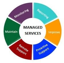 Our managed service offering has been designed to manage and maintain your GIS applications and data in a round-the-clock fashion. We managed service team follows the proven processes and ensure maintenance of their SLA’s with our clients. They provide 24×7 helpdesk and support services and are able to resolve your issues within acceptable timeframes to the desired levels of satisfaction. Our managed services team takes care of your GIS data updates, GIS work order posting and data conversion and also, perform quality testing of your GIS applications.
Network Asset Management
 In order to manage your geographically distributed network assets, we offer our network asset management services. These assets may be drainage systems, pipelines, optical fibre networks, underground circuits, pavements. These all assets need to be linked directly to your information systems in order to allow you to monitor progress of the work, ensure smooth working of your network using GIS. We facilitate work and asset management using our expertise in integration of geographically scattered assets into your business systems. We undertake GIS transformation projects that involve maintenance and transformation of spatial data.
Land Management
 Land management experts at Vision International understand the spatial extent and usage of land information so that we can help organize the land records data for an effective planning. Land records data management is often a daunting task, which can be eased up with our land management engagement. We also help our clients with land valuation, land parcels’ mapping, and integrating land records to allow assessment of infrastructure for suitability of specific purposes and better management of land resources.
We also help our clients in their smart governance and e-governance enablement initiatives at various stages. Including the analysis of current governance practices, reviews, recommendations, planning, project execution and staff training, we are able to help at any/all stages whilst giving you the benefit of our strong technological foundation along the course.
Risk Management
 Geo-informatics can help you understand any possible hazards and the risks associated with your widespread network assets. Our geo-informatics services are designed to give you an excellent view of such hazards and facilitate disaster management and outage management. We help develop risk profiles and prepare risk mitigation mechanisms considering the information like location-based data, road access, traffic flow patterns, vegetation density etc.
We also help our clients with claims analysis and management by optimizing their claims workflow. Our team ensures that your staff members get the most accurate location-based information to understand the losses your customers suffered and to devise plans to meet their needs precisely.